NEAREST TAB
The Nearest Tab (keyboard shortcut [Alt]+6) allows you to create and maintain lists of branch offices, regional centres or contacts, then quickly determine which contact point is nearest the postcode you enter into the Find Box.
The Nearest facility uses the Grid References supplied as part of Postcode Plus data, to calculate the approximate linear distances between postcodes.
Please note: These distances are 'As the Crow Flies', and will not be accurate travel distances. Most major expanses of water, mountain ranges, and other obstacles are taken account of to help ensure that the closest address is shown first. However, in some cases because of local road layouts or geography the 'Nearest' address may not be the easiest or most practical to reach - so others further down the ranked list may be more appropriate.
To use Nearest you must first either create a New Database or Select an existing one - see below.
If you wish to create a new database to start building a nearest list from scratch then select 'New Database' from the 'Nearest' menu. This will create a new Microsoft Access database ready for adding records.
Access, Paradox, dBASE and FoxPro Tables
If you wish to use a non-ODBC database that you created before or one built up using another program choose 'Open Database' from the 'Nearest' menu. This will prompt you to select the database that you wish to use.
For Access databases you will also be prompted to select the table you wish to use if more than one exists in your chosen database file.
Nearest will use the following fields if they exist in the selected database table:
* Postcode DPS Title Organisation Property Street Locality Town County Km Miles Filter Notes *
GridE *
GridN Surname Firstname Initial Phone Fax WWW * must exist in the table and must contain a value.
All fields must be of type 'Text' or equivalent.For System Managers who have special requirements in linking or customising existing databases with the Postcode Nearest facility, our Help Desk will be pleased to provide further information.
ODBC Tables
If you wish to open a connection to an ODBC data source to which you have set up a Data Source Name (DSN) choose 'Open ODBC Connection' from the Nearest menu. You will be prompted to enter the DSN, authentication details (if required), and the SQL Query String to connect to the table.
Fields will be used in the same way as described in the above section.
To add records to the nearest table simply use the Search tab to search for the records you require. Select those you wish to add to the nearest database and then select 'Add Records' from the 'Nearest' menu to add them (or use the shortcut key [Ctrl] + A). Alternatively if you wish to add all the records in the results list to the nearest database use the 'Add All Records' menu item.
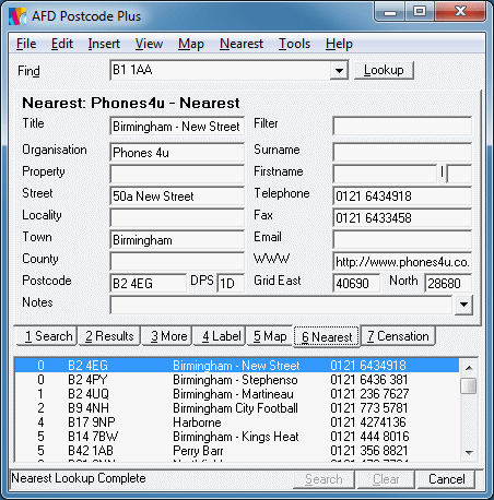
To find the nearest record to a postcode, enter the postcode in the 'Lookup' box. Results will be ranked in order of distance away from your postcode. The 'Display Miles' and 'Display Kilometers' options on the 'Nearest' menu can be used to determine the units used for the distance displayed for the results.
To update a record in the Nearest database, simply select the record from the list under the Nearest tab and then type into the fields on the tab itself. Once you are happy with your changes select 'Save Record' from the 'Nearest' menu or use the shortcut [Ctrl]+S to save your changes to the database.
System managers may disable the update facilities.
If you wish to remove records from the Nearest database, simply select the records you wish to delete from the list under the Nearest tab and then select 'Delete Selected Records' from the 'Nearest' menu or use the keyboard shortcut [Ctrl]+K.
System managers may disable the delete facility.
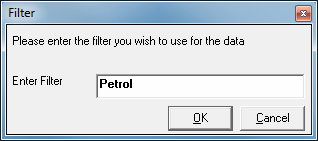
The Filter field of a database, if present, allows you to assign a value to each record for grouping. By selecting the 'Filter' option from the 'Nearest' menu ([CTRL]+F) you can enter a pattern to apply to the filter field to display only records matching that Filter.
For example, in a database of supermarkets with a filter field containing values such as "Groceries, Petrol, Clothing" a Filter field of "Petrol" will return only those stores which include a Petrol Station.
To allow multiple groupings various wildcard characters, character lists, and character ranges are available to test only part of the filter:
| Code | Action | |
| {None} | All Nearest Records | |
| ? | Any Character | |
| * | Zero or more characters | |
| # | Any single digit (0-9) | |
| [charlist] | Any single character in charlist | |
| [!charlist] | Any single character not in charlist |
If you are using an external database, have imported records without Grid References, or have some incorrect Grid References they will need to be populated from the Postcode Plus data. To do this select the records in the nearest list that require Grid References and select 'Lookup Grid References' from the 'Nearest' menu. You will be prompted for action if an existing Grid Reference is found for any of the records.
Making Labels from Nearest Records
To use the Label feature with a Nearest Record, simply select the Nearest record you would like a label for and then select 'Transfer To Label Tab' from the 'Nearest' menu, to transfer the record to the Label tab.
Showing the Position of a Nearest Record
To use the Map feature to view the position of a Nearest Record, simply select the Nearest record you would like to view on the map and then select 'Transfer To Map Tab' from the 'Nearest' menu, to transfer the record to the Map tab.
Nearest locations are also displayed on the map as blue boxes containing a crosshair if the 'Display Nearest Locations' option is checked on the Map menu.
Viewing Distances to One Decimal Place.
If you have several outlets in close proximity and need to be able to distinguish between them you can select to have Nearest distances displayed down to an accuracy of one decimal place. This can be done by selecting the 'Show Decimal Place' option from the Nearest menu.
Importing and Exporting Records
Records can be imported from or exported to comma delimited text files.
To use this facility, simply select the 'Import Records' or 'Export Records' on the 'Nearest' menu - you will be prompted for a filename in both cases. The 'Export' option only exports the selected records. 'Import' imports all records in the supplied file.
Please note: Whether the files have been imported or exported they must have all the fields below in the order they appear below:
| * | Postcode | DPS | * | Title | Organisation | Property | Street | |
| Locality | Town | County | Km | Miles | Filter | |||
| Notes | GridE | GridN | Surname | Firstname | Initial | |||
| Phone | Fax | WWW | ||||||
| * | must contain a value | |||||||