MORE TAB
Using the More Tab
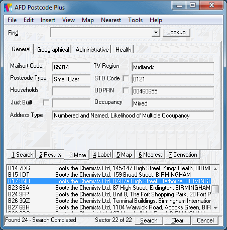
This tab is used to display less-commonly used Additional Information provided by Postcode Plus. It can be selected by clicking the tab - or use the [Alt]+[3] keyboard shortcut.
- Large User Organisation (Single Organisation on this postcode)
- Small User Organisation (All the properties on this postcode are likely to be businesses)
- Mostly Organisations (Most of the properties on this postcode are organisations)
- Mixed (This postcode contains a mixture of business and residential addresses)
- Mostly Residential (Most of the properties on this postcode are residential)
- Residential (All the properties on this postcode are likely to be residential).
- Numbered (Only a property number needs to be captured)
- Numbered and Named (This postcode contains a mixture of properties needing a property number and those needing a property name (including properties such as 16b)
- Numbered and Named, Likelihood of Multiple Occupancy (This postcode contains a mixture of properties needing a property number and those needing a property name. Some of the properties on this postcode are likely to contain multiple occupants, e.g. flats).
- Named (This postcode only contains properties needing a property name).
- Non-Standard Address Format (This refers to addresses which do not have a street field at all, or have multiple street names on the same postcode. This also includes addresses with numbered localities (no street but a house number which goes in with the locality field). It is in-effect a warning to be careful in capturing the property information as it is not in one of the most common address formats).
- PO Box (This postcode has a PO Box number)
- No Property Information (Addresses on this postcode have no property information - i.e. capture an Organisation or Resident name only)
These fields are grouped into Tabs to organise the available data. If you have commonly used data items that you wish to see alongside the address you can configure Postcode Plus to display up to four of these fields on the Results Tab.
This tab includes the following data:
| Field | Meaning |
| General | |
| Mailsort Code | The code is assigned by Royal Mail and used to sort mail for discounts. |
| TV Region | The TV Region (ISBA Region - not TV Company) the postcode falls into |
| Postcode Type | Indicates if this is a large or small user postcode. A large user postcode always contains a single organisation, a small user postcode is normally shared between a number of organisations and/or residential properties. |
| STD Code | An indication of the STD Code for the location that this postcode is in. Please note that STD Code boundaries do not follow address areas exactly and often multiple codes are found in the same area. Hence this is only an indication of the possible STD Code. |
| Households | Indicates the number of households sharing the same delivery point, e.g. if four flats within a house all share the same letter box this will be set to 4. |
| UDPRN | This is the Royal Mail Unique Delivery Point Reference Number assigned to an individual delivery point (address). Sometimes address details change, for example the postcode may change as the result of a recoding, or the building may be renamed, etc. The UDPRN for an address should stay constant when these changes occur. |
| AFD Just Built � | This provides an indication that a property is likely to be a new build. It contains the date that the property came onto AFD Postcode Plus. This number is expressed in the form YYYYMMDD, e.g. 20080614 means it was introduced On 14th June 2008. |
| Occupancy | This gives an indication of the type of occupants of
properties found on the selected postcode. The possible values for
this are as follows:
|
| Address Type | This gives an indication of the type of property level
data you will need to capture to have the full address for properties on
the selected postcode. The possible values for this are as
follows:
Please refer to Appendix L for more information regarding the Occupancy and Address Type indicators in Postcode Plus. |
| Geographical | |
| Grid East and North | A 10 digit grid reference relating to the location of the postcode on the National Grid, or the Irish Grid for postcodes in Northern Ireland (starting BT). These are to a resolution of 100m. Please refer to Appendix C for more information regarding Grid References in Postcode Plus. |
| Distance | Specifies the Distance in Km or Miles from the specified grid reference when carrying out a radial search. |
| Latitude and Longitude | The corresponding latitude and longitude values for the given Grid Easting and Northing for this postcode. These are based on the WGS84 standard. |
| Urban Rural Code | This is a code assigned to the output area for
this postcode which indicates if it is in an area of mainly urban or
rural properties and how sparsely populated those area's are. Note
that different codes are used for England & Wales, Scotland and
Northern Ireland. The Scottish codes are prefixed with an 'S' to distinguish
them from those for England & Wales as they are both numeric.
The possible codes are as follows:
England & Wales Scotland Northern Ireland |
| Urban Rural | This provides a description that corresponds to the urban rural code. |
| Administrative | |
| Ward Code | Code identifying the electoral ward the postcode resides in |
| Ward Name | The name of the electoral ward the postcode resides in |
| Authority Code | Gives the code of the Local or Unitary Authority (which ever is relevant) this Postcode is contained in (Same as the start of the Ward Code) |
| Authority | Gives the name of the Local or Unitary Authority (which ever is relevant) this Postcode is contained in |
| EER Code | Provides the code of the European Electoral Region that this postcode falls into |
| EER Name | Provides the name of the European Electoral Region that this postcode falls into |
| LEA Code | Provides the code of the Local Education Authority that this postcode falls into |
| LEA Name | Provides the name of the Local Education Authority that this postcode falls into |
| Constituency | The electoral Constituency the postcode falls into |
| Health | |
| NHS Code | National Health Service Area Code. This is: Strategic Health Authority (England) Health Board (Scotland) Health and Social Services Boards (Northern Ireland) (Pseudo code for Wales (see PCT Code) |
| NHS Area | National Health Service Area Name which corresponds to the NHS Code. |
| NHS Region Code | National Health Service Region Code (Regional Office - applies to England only). This is no longer in use by the NHS and the field will likely be removed. |
| NHS Region | National Health Service Region Name. This is no longer in use by the NHS and the field will likely be removed. |
| PCT Code | National Heath Service Primary Care Trust Code for England (Local Health Board Code in Wales, Community Health Partnership in Scotland) |
| PCT Name | National Heath Service Primary Care Trust Name for England (Local Health Board Name in Wales, Community Health Partnership in Scotland) |
Searching on More Tab Information
Some of the fields on the this tab (e.g. the Grid reference fields) can also be used as part of a search (alone or in conjunction with the Search Tab). To include one of the Additional Information fields, simply enter the information, and click the check-box next to the field (or fields) you wish to use in searches.
You can drag text from the individual fields of the More Tab and drop it into other Windows programs - like Microsoft Word.
Hold down one of the [Shift] keys (usually marked with a hollow arrow pointing upwards). Then click and hold down the left mouse button on the field you wish to move (drag) text FROM - the cursor will turn into a dragging icon. Now move to the program you wish to place the text in (keeping the mouse button down). Finally, release the mouse button to drop the text in the new field.