On Top
-
If you prefer Postcode Plus to float 'On Top' of other Windows programs - even when you are not working directly in Postcode Plus, select the View menu On Top option (shortcut key [Ctrl]+T). Postcode Plus will display a check-mark next to this option whilst it is in use.
-
Postcode Plus allows a shortcut key to be used to quickly access the Postcode Plus application. To configure or view the currently assigned Hotkey setting, select the File menu Properties option. ([Crtl]+R)
Enabling the Hotkey allows Postcode Plus to be launched on pressing the configured Hotkey even if it is not already running.
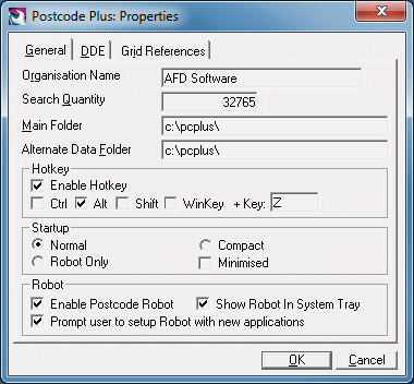
Care should be taken in ensuring the Hotkey is assigned to a key combination that will not conflict with shortcut keys used by other applications (for example [Ctrl]+P is often used as a shortcut to print so if you assign [Ctrl]+P then you won't be able to use that shortcut key to print from applications).
Please note: WinKey refers to the Windows Key (˙) on your keyboard.
With printable characters, simply press the key in the 'Key' box to use that key with Postcode, for non-printable characters such as F1, Insert, Print Screen etc. enter the code in curly brackets as shown in the following table:
Backspace {BS} Enter/Return {ENTER} Page Up {PGUP} Page Down {PGDN} Home {HOME} End {END} Left Arrow {LEFT} Right Arrow {RIGHT} Up Arrow {UP} Down Arrow {DOWN} F# (Function Keys) {F#} Insert {INSERT} Left Menu Key {LMENU} Right Menu Key {RMENU} The Hotkey is fully configurable and can be configured to be used with any keyboard key.
Please note: Some have been omitted because they would cause problems with Windows.
However any key on any keyboard can be used, email support@afd.co.uk, or phone the AFD Support Team (01624 811712) if you need help setting up the Hotkey.
Postcode Plus contains grid references for most Postcodes in PAF (Some postcodes, such as PO Boxes as they are non-geographical, do not have Grid References). Also displayed is the latitude and longitude values corresponding to these grid references. This is in WGS84 format which is most commonly used by GPS units. You can change the options for how these grid references and latitude and longitude values are displayed from the Properties screen, accessible from by selecting Properties from the File menu.
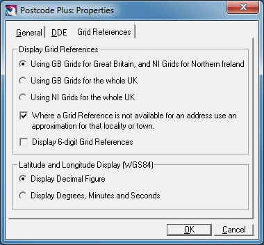
Here you can choose how grid references are displayed. By default British grid references are used for British postcodes and Irish Grids for Irish Postcodes. However in some cases you might wish to standardise on one or the other, for example when comparing distances between them so you can select to always use either GB (British) or NI (Irish) grid references.
Also available is the option to use an approximation for the locality or town an address is located in when a grid reference is not available. This is of course a lot less precise in the case where a grid reference is not available for the postcode itself, but may be more useful than a blank grid reference for uses such as finding distances, locating an address on the Map etc.
These grid reference options are made use of on the Results tab and the Map tab and taken account of in Inserting addresses as well. However it should be noted that the Nearest function always uses GB Grid references for consistency across the whole UK in determining distances.
For the latitude and longitude display and for inserting these values you can choose if you wish to use the decimal or degrees, minutes and seconds display. Generally the decimal display is more useful for entering into other programs etc, but the degrees display is more easily readable.
For more information about Grid References see the Grid References Appendix.
Available In Postcode Plus Listmaker versions only
Postcode Plus can export address data ready for use in word-processors for mail-merge or for import into spreadsheets and databases.
Select the File menu Export option (shortcut key [Ctrl]+E), and choose a suitable file name. Export files are stored as 'Quoted Comma Separated ASCII' text files - which can be easily read by most word-processors, spreadsheets and database programs.
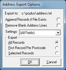
The following Export options are available:
Append Records if File Exists
This feature allows records to be built up from several searches and written to the same file. If it is not checked then any existing file of the same name is overwritten with this export.
Remove Blank Address Lines
This feature is similar to Postcode Plus' Insert Settings Line Squeeze option - in that it will remove blank lines from addresses as they are stored. This will be useful for creating export files to be used in word-processors, but would not be required if your file is to be imported into a database - where the position of the address fields would be important.
Settings
This option is useful when you wish to export special fields, such
as the building number separate from the other address information or need the
data in some particular format and order for whatever reason. Rather than
the default 'All Fields' setting you can select any of the Insert/Robot settings
stored in Names & Numbers. The fields specified in that setting set
will be used (ignoring the Before and After keystrokes). To add a new
setting specifically for export simply add a settings set for an arbitrary
application and then select that set from here. For information regarding
how to setup an Insert or Robot settings set please refer to the Insert
section of this manual.
Export All, First or Selected Records
Choose whether all the records in the Results List, just the records you have manually selected from the Results List or the first record for each postcode should be exported.
To select records from the Results List manually, use the [Ctrl] key plus the left mouse button to choose multiple records randomly from the list.